
Riverine Operations
1966 - 1969
![]()
Chapter I:
During 1965 and 1966 when the possibility of creating a
U.S. riverine force for operations in the Mekong Delta was being discussed,
there were three basic considerations that weighed heavily in favor of the
force: a tradition of past American success in riverine operations, particularly
Union operations in the Mississippi basin during the Civil War; the success more
recently achieved by the French in riverine operations during the Indochina War
under conditions that appeared to have, changed little during the years that had
intervened; and, most important, a situation in the Mekong Delta that seemed
ripe for exploitation by a riverine force.
American forces conducted riverine operations as early as the Revolutionary War and made use of them frequently during the century that followed. In each case, the operations were part of a larger land campaign. While they were not always tactically successful, they usually made a substantial contribution to the success of the campaign.
In 1775, on the heels of the battles of Lexington and Concord, both the Americans and British sought to gain control of the strategic Hudson River-Lake Champlain-St. Lawrence River waterway system connecting New York and the British centers in Canada. Forces under Colonels Benedict Arnold and Ethan Allan seized the British forts at Ticonderoga and Crown Point; Arnold then armed a captured schooner and pressed north along Lake Champlain to attack the British base at St. Johns on the Richelieu River above the lake. In a daring surprise attack, he captured or destroyed a large number of boats and considerable amounts of supplies and equipment before returning to Lake Champlain. By means of this lake and river operation, Arnold effectually blunted the British ability to counterattack.
Pressing their advantage, the Americans then undertook an invasion of Canada, with one line of advance up the lake and river
[3]
chain. Their attack on Quebec was repulsed, and by the spring of 1776 the British, heavily reinforced from the home country, regained the offensive. The British began to assemble a fleet at St. Johns. Some of the larger vessels were actually built in England, knocked down for shipment across the ocean, and reassembled at St. Johns. Spurred on by Benedict Arnold, the Americans sought to keep pace with the British at their- own Skenesborough shipyard, near the southern end of Lake Champlain. On 11 October 1776 the Americans, with a fleet of fifteen boats hastily constructed of green timber. and manned by a scratch force of backwoodsmen and recruits from the seacoast-"the flotsam of the waterfront and the jetsam from the taverns"-engaged the formidable British force of twenty-nine vessels at Valcour Island, just north of Ticonderoga. The poorly organized and ill-equipped American force lost its ships one by one, and the Americans were forced to retire to Crown Point. The British tenaciously pursued and drove Arnold's force out of Crown Point into Ticonderoga at the southern tip of the lake. Although Arnold had lost the engagement, his small flotilla delayed the British advance until the following year, when Major General John Burgoyne attempted a thrust southward to cut the colonies in two and was defeated at Saratoga.
Some thirty-five years later in the War of 1812, U.S. forces again fought the British on American waterways. In 1813 Commodore Oliver H. Perry assembled a fleet on Lake Erie to counter the British threat from Canada, and by defeating the British fleet in a series of engagements gained control of the Great Lakes, permitting a subsequent American advance into Canada. During the next year the British made three major attempts to exploit inland waterways: one from Chesapeake Bay against Washington, a second overland from Canada toward New York, and a third from the Gulf of Mexico against New Orleans. Each British effort was met by an opposing American riverine force. In August 1814 British forces pushing up the Chesapeake were met by a force under Commodore Joshua Barney. After several engagements in which Barney's initiative and dogged persistence frustrated the British advance, the British disembarked at Benedict, Maryland, and then marched the thirty-one miles to Washington, where they burned the public buildings. The British drive down Lake Champlain was blocked in September 1814 by American Commodore Thomas MacDonough in the river battle of Plattsburg.
A few months later, in December 1814, the British moved against New Orleans, connected to the Gulf of Mexico by the lakes
[4]
and bayous of the Mississippi Delta. While the British assembled forces off the coast, American Commodore Daniel T. Patterson prepared his river forces to oppose the attack. He placed obstructions in the waterways leading directly to the city, and with five gunboats and two tenders met the advancing British forces on lake Borgne. Outgunned and Outmaneuvered, Patterson was thoroughly beaten. Despite his defeat he continued with the remnants of his shallow-water navy to oppose the British advance with skill and energy, thus gaining enough time to permit General Andrew Jackson to ready the defenses of the city. Then Patterson, with the Carolina and the Louisiana, his two largest ships, deployed on the river, joined forces with Jackson in a defense that resulted in ultimate defeat of the British.
Prom 1835 to 1842 Army and Navy forces fought in the Florida Everglades against the Creeks and the Seminoles in a particularly frustrating and indecisive campaign. To navigate the inlets along the coast as well as the waterway mazes of the swamps, a mosquito fleet of some 150 craft-schooners, flat-bottomed boats, bateaux, and canoes-was assembled and manned by soldiers, sailors, and marines. Operating in conjunction with Army Colonel William J. Worth, Navy Lieutenant John T. McLaughlin transported men, equipment, and supplies, patrolled waterways, and conducted raids. Because of its mobility and striking power, the riverine force, well adapted to conditions in the Everglades, was able to reduce the Indian threat.
A few years later during the War with Mexico, 1846-1848, the American Navy conducted two river raids which, although not particularly decisive in themselves, made a strong impression on one of the younger participants, Lieutenant David Dixon Porter, who was to use the experience in another war. The raids were conducted some seventy-five miles up the Tabasco River against San Juan Bautista, an enemy crossing point and operating base. Commodore Matthew C. Perry utilized steamers to tow two sailing schooners and smaller craft up the winding river against a strong current. On his first raid he bombarded the city without debarking any troops. On his second, he landed a force of 2,500 sailors and marines, which had been formed into infantry and artillery divisions, and assaulted the city from the shore, supported by fire from the force afloat that included four steam warships, six schooners, some "bomb rigs" that mounted mortars, and a number of ships' boats. While Perry was ashore leading leis men, the ships and boats were left under the command of Lieutenant Porter.
[5]
Extensive riverine operations were conducted during the Civil War. Along the coasts of the Confederacy, the Union launched joint Army-Navy expeditions that gradually gained footholds in the vicinity of Mobile, Alabama; Savannah, Georgia; Charleston, South Carolina; and Wilmington, North Carolina. At the same time there was a concerted Army-Navy effort to control the inland waterways of the Mississippi basin and thus cut the Confederacy in two. At the outset, Union Commodore ,John D. Rodgers assembled a fleet of steam-powered, shallow-draft vessels at Cairo, Illinois, where the Ohio River flows into the Mississippi. The gunboats were well armed and well armored, could carry a dozen large guns 8-inch, 32- and 42-pounders-and ranged up to a 50-foot beam and a length of 175 feet, with ironclad, sloping superstructures. Rodgers used his craft to patrol and gather intelligence of the Confederate forces that lay within striking distance. Relying in part on the intelligence Rodgers obtained, Brigadier General Ulysses S. Grant decided to move against Confederate forces at Belmont, Missouri. Rodgers transported 3,000 of Grant's men and provided fire support for the operation. When substantial Confederate reinforcements arrived unexpectedly to bolster the garrison at Belmont, Grant prudently re-embarked and withdrew, demonstrating that river craft may be as useful in a withdrawal as they are in an advance.
Soon afterward, Commodore Andrew H. Foote, who succeeded Rodgers, and General Grant requested permission to undertake offensive river operations. In January 1862 their plan for a joint Army-Navy operation was approved. In February the combined forces moved up the Ohio River and then the Tennessee River to attack Confederate Fort Henry. The force used regular civilian transports as well as the specialized shallow-water gunboats. Grant landed his men five miles above the fort and advanced overland. The gunboats began the attack alone, firing as they approached the fort. They closed to point-blank range, silenced the Confederate shore batteries, and unexpectedly forced the surrender of the garrison. It was a riverine victory for Union forces, and the news was welcome in Washington, where it contrasted dramatically with disappointing reports from other areas.
The victory at Fort Henry was followed by Navy gunboat raids up the Tennessee River. The raids ranged across the entire state of Tennessee, probed into Mississippi, and even pushed into Alabama as far as Muscle Shoals. At the same time, General Grant and Commodore Foote moved against nearby Confederate Fort Donel-
[6]
son, which lay on the Cumberland River and covered the land routes to Nashville. Grant moved most of his troops directly overland, while Foote descended the Cumberland to the Ohio, then sailed up the Tennessee. The battle began when Foote moved his gunboats against the Confederate shore batteries. Heavy fire from the shore soon forced the gunboats to withdraw; each of the six ships took twenty or more hits and two ships were put out of action. Casualties were high and included Commodore Foote, who was seriously wounded. Later, under renewed Union attack from river and shore, the Confederate a garrison surrendered. While Fort Henry was essentially a Navy victory, it was a combination of Army and Navy forces that proved decisive at Fort Donelson.
Shortly thereafter the Union Navy in the Gulf of Mexico moved inland against New Orleans. Forces under Admiral David Glasgow Farragut first crossed the sandbar at the mouth of the Mississippi, then re-rigged ships for river operations. Farragut directed a five-day bombardment by a specially prepared mortar flotilla to soften up the Confederate defenses along the river. He assembled his force and in a daring night maneuver ran the gauntlet of forts and Confederate warships that blocked the way. Once he had penetrated the Confederate defenses, he moved on unopposed to his objective. With a force of less than 3,500 men, he succeeded in capturing the South's largest city.
Although he had achieved success, Farragut was nonetheless impressed by some of the difficulties, which his deepwater force had encountered on the river. He wrote, "Fighting is nothing to the evils of the river-getting on shore, running afoul of one another, losing anchors, etc."
A few weeks later, in June 1862, Farragut moved up the Mississippi and tried to seize Vicksburg but was repulsed. He succeeded, however, in running by the Confederate fortifications to link up with Navy forces under Captain Charles Henry Davis, who had relieved Commodore Foote. The combined flotillas then operated in support of Grant. Confederate resistance at Vicksburg prevented further passage along the river and delayed Union attempts to split the Confederacy. It was nearly a year before Grant could force the surrender of the city. During Farragut's June operations, Union Navy forces in the vicinity of Vicksburg were under the command of Rear Admiral David Dixon Porter, who had earlier taken part in river warfare in Mexico. Throughout the campaign of the lower Mississippi, the Confederates skillfully used water mines-torpedoes, as they were called-to counter the riverine
[7]
threat. Some forty Union craft fell victim to these torpedoes. Confederate snipers and shore batteries as well as such navigational difficulties as shallow " water and tree stumps also helped to frustrate Union attempts on Vicksburg.
In the end, Navy forces from the north succeeded in running the gauntlet at Vicksburg. Grant's brilliant maneuvering first to the south and then to the east of the fortress defeated the Confederate forces that might have come to the relief of Vicksburg, permitting Grant to bring about its surrender. The fall of Vicksburg split the Confederacy in two: Union control of the Mississippi, the Ohio, the Cumberland, and the Tennessee proved decisive in the final Union victory.
For many years after the Civil War the United States had
little occasion to engage in riverine warfare. Perhaps the most notable U.S.
river operation in the early twentieth century was the American Navy's patrol of
the Yangtze River after the Boxer Rebellion in China. During the twenties and
thirties a flotilla of U.S. Navy gunboats known as the Yangtze Patrol maneuvered
along some 1,500 miles of meandering river, faced with occasionally swift
currents, and with water levels that were subject to sudden and violent
change-up to twenty-four feet in twenty-four hours. In addition to the
difficulties of navigating the Yangtze, the patrol had to cope with snipers,
ambushes rigged by warlords, and the necessity to conduct rescue missions that
sometimes required the use of landing parties. During World War II American
forces were used in some operations that might be termed riverine warfare, but
it was not until the Vietnam War that the United States organized a complicated
river flotilla to fight on inland waterways.
French
River Warfare in Indochina, 1945-1954
During the nineteenth century the French had used the waterways of the Mekong and the Red River Deltas in their conquest of Indochina. When French forces returned to Vietnam in 1945 after World War II in an attempt to regain control of the country, they used conventional military tactics at first and such riverine operations as were launched were characterized by improvisation, but in the next nine years the French developed a remarkable riverine force.
In the north, in Tonkin, where most of the fighting occurred, the delta formed by the combined Red, Black, and Clear Rivers, and in the south, in Cochinchina, the delta formed by the Mekong, the Bassac, the Dong Nai, the Saigon, and the Vain Co rivers
[8]

[9]
offered mazes of meandering streams connected here and there by straight canals. (Map 1) Even in peacetime most of the traffic in tile north of Vietnam was fly waterway. In wartime, with roads and railroads frequently cut lay enemy action, the French estimated that 90 percent of traffic was fly inland waterway. It was not surprising, therefore, that tile French should turn to these waterways for military operations.
Tile French started out with craft that were available
locally-native or left by the Japanese-which they modified with armor and
armament. In addition, they received from the British some LCI's (landing craft,
infantry) and a few LCA's (landing craft, assault) and LCT's (landing craft,
tank) . The French Army created a number of river flotillas that were used for
transport and river patrols. By 1046 tile French Navy had organized river
flotillas and in 1947 these were designated divisions navales d'assaut (naval
assault divisions) , abbreviated to Dinassauts. The divisions were organized
initially to provide transport with fire support escort. In time their
composition changed, and one flotilla differed from another according to tile
area in which it operated. Each flotilla had from twelve to eighteen craft,
ranging from LCVP's (landing craft, vehicle or personnel) to LSSL's (landing
ships, support, large) , and contained at least these elements:
|
Command and fire support |
1 LCI or LSSL |
|
Transport |
1 LCT |
|
Landing and support |
2 LCM's and 4 LCVP's |
|
Patrol and Liaison |
1 harbor patrol boat |
The flotilla could transport and land a force of approximately battalion size and its equipment. It could also support the landing force by fire and control the waterways in the vicinity of the landing area. The river flotilla could do some patrolling, and even some raiding in support of tile main operating force ashore. Toward the end of the campaign as the Viet Minh massed their forces, the single river flotilla proved inadequate and the French organized river task forces consisting of several flotillas, reinforced by additional troop transports. In addition to these naval units, the French had other specialized units, organized and manned by the Army for river operations; solve were built around vehicles of tile Crab and Alligator type and some supply units were equipped with LCM's (landing craft, mechanized) .
Command relations between French Army and Navy elements varied, but the Navy generally operated the vessels and provided support to Army operations. In Tonkin the Commander, River
[10]
Forces, maintained close liaison with Headquarters, Ground Forces, North Vietnam, and to all intents and purposes the four flotillas in the area operated in support of the Army. In Cochinchina the River Forces Command provided support to the Commanding General. Ground Forces, South Vietnam, as agreed with the Commander, French Naval Forces, Indochina.
These arrangements appeared to the French commanders, even in retrospect, to have been satisfactory, although there seems to have been some Army complaint that there were not enough landing craft, and some Navy complaint that the local Navy commanders had no organic infantry capable of defending Navy bases, either fixed or afloat. The naval command was responsible for all river forces regardless of their parent service. Thus, French Army troops transported by a Dinassaut were tinder operational control of the French Navy. Coordination with the Army was achieved through river posts, which maintained direct liaison with ground force commanders in their areas. A continuing difficulty was the problem of Dinassaut base defense. Generally, each Dinassaut had a small Navy Commando detachment or an Army light support company attached to it. But the Dinassaut did not have regular battalion strength landing forces permanently assigned; these would have permitted greater autonomy and better control of an area between major operations. The infantry landing forces, when made available by the Army for a particular operation, usually lacked training or experience in river warfare.
A river assault flotilla generally deployed in column. Leading the column was an opening group of minesweepers and a guide for navigation, followed by a fire support ship. Next came the troop transports and, bringing up the rear, the command and support vessels. (Diagram 1) When a flotilla was attacked it usually attempted to force passage, using what the French called "the ball of fire," or heaviest possible volume of immediate fire directed at enemy positions on shore. One theory held that when there was reason to suspect an ambush, a direct assault against the enemy was most effective; such improvised assaults, however, were rare. In an assault the opening group consisted of a guide ship and minesweepers. Close behind was the shock group, consisting of a command vessel, one or more fire support ships, and several landing craft carrying the assault troops. The remainder of the force trailed at a distance of 1,000 to 1,500 meters. Upon arrival at the assault site, the shock group would fire a preparation bombardment Tent and the assault troops would then land. Once the landing site was se-
[11]
|
Opening group |
1 LCM Monitor (guide) 1 Mine sweeper (replacement) |
|
|
Suport1 |
1 LSIL |
|
|
Transport ships and craft2 |
1 LSM
1 Support ship in the center of the convoy |
|
|
Command and Support 1 |
1 LSIL or LSSL (force commander) |
1 When there was but one support ship, it took the
lead and was the command ship. When there were two support ships, the command
ship was in the rear; when there were three, the command ship was in the center.
The lead support ship might also be an LSSL, an armed LCT, or a section of LCM
monitors (2 boats).
2 Sometimes the transport craft were in two columns, lashed in pairs.
Diagram 1. A typical French river convoy in North Vietnam.
cured, the remainder of the landing force would beach and unload. During the landing and until the river craft were withdrawn, the force afloat provided fire support, protected the flanks of the land-
[12]
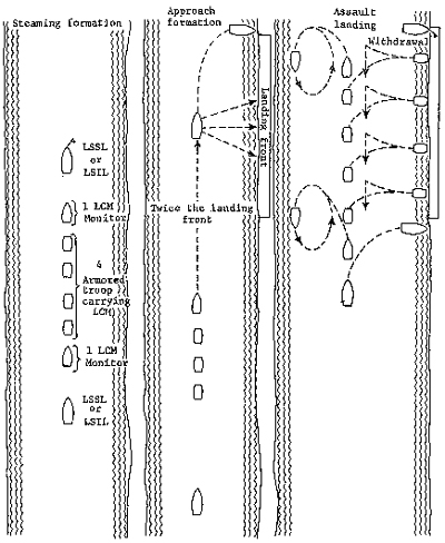
Diagram 2. French assault landing.
ing site, and patrolled in the vicinity to provide additional security. Some craft were used for logistic support, and the larger ships served temporarily as command posts for the ground unit commanders. (Diagram 2)
French reports show that during the entire campaign from 1945 through 1954 losses from attack while vessels were at anchor exceeded those suffered while a convoy was under way. Most Viet Minh attacks against French river forces were carefully planned
[13]
and made use of some combination of swimmers, drifting mines, artillery and mortar fire, and occasionally overland assaults. French countermeasures had spotty success. Nets were used with ebb and flow of the tide to trap mines; security watches were set up; all floating objects were systematically fired upon; patrol craft were sent out; grenade attacks were made at irregular intervals and on unidentified objects; and lights were installed at entrances to anchorages.
Harassing enemy mortar and artillery fire proved particularly effective, causing the French to withdraw some forces that otherwise would have remained on station. French commanders discovered they could not rely on passive measures alone. They were sometimes obliged to shift anchorages during darkness to avoid planned Viet Minh fire. When boats were beached it proved necessary to cover the beach front with a ground unit.
The river assault flotillas were rarely employed in coastal operations, since craft modified for river use were less seaworthy, had less cargo capacity, and had armored superstructures that hindered troop transfers. Troops experienced in riverine assaults required extensive additional training for coastal operations before they were able to master going down cargo nets with their equipment, even when the sea was calm.
The tempo of French riverine operations increased steadily from 1946 until the end of the war in 1954. The Dinassauts played a key role in the battles for the Red River Delta from the summer of 1951 through early 1952. During the battle of Ninh Binh, 29 May-18 June 1951, 100 kilometers south of Hanoi on the Day River, a Dinassaut reinforced the French garrison, provided fire support, cut enemy communications, and helped to force the Viet Minh to withdraw.
During the battle of Hoa Binh, 14 November 1951-24 February 1952, sixty kilometers west of Hanoi on the Black River, two Dinassauts escorted convoys through a sector in which one bank of the river was controlled by the enemy for a distance of about fifty kilometers. As the Viet Minh increased pressure on the lines of communication connecting the garrison at Hoa Binh with the main French forces to the east, the overland routes were severed. The Dinassauts, however, continued to run the gauntlet until 12 January 1952, when an entire river convoy was ambushed and took heavy losses. Finally, when the decision was made to evacuate Hoa Binh-Operation Armaranth-the Dinassauts supported the operation by reopening the Black River corridor, ferrying retreating
[14]
troops and refugees, then fighting their way out along the river toward Hanoi. Later, two Dinassauts played a key role in the offensive phase of Operation Lorraine, 29 October-8 November 1952, northwest of Hanoi on the Clear and Red Rivers.
By the end of the war, French riverine forces were fully committed and were taking heavy casualties. In over a dozen ambushes fourteen naval craft were sunk or damaged, with nearly 100 men killed or wounded. (Table 1)
TABLE 1-VIET MINH RIVER AMBUSHES, 5 JANUARY-16 FEBRUARY 1954
|
Date |
Waterway |
Group
or Type |
Enemy
Weapons |
Comments |
|
5 January |
Song Thai Binh |
Dinassaut 4 |
Mine |
LSIL sunk; Navy,10 killed or missing, including 2
officers; Army, 40 wounded |
|
13 January |
Red River |
Dinassaut12 |
Automatic Weapons |
|
|
14 January |
Bamboo Canal |
Dinassaut 4, Javeline |
Mine |
|
|
15 January |
Nam Dinh Giant |
LCT 9.063, barge convoy, and LCM |
Bazooka, automatic weapons |
1 barge sunk; Navy, 4 wounded; Army, 1 Killed |
|
20 January |
Song Thai Binh |
Platoon river patrol boat |
Bazooka, automatic weapons |
1 launch sunk, 2 killed, 3 army wounded |
|
22 January |
Song Thai Dinh |
Dinassaut 1 |
Bazooka, automatic weapons |
Detected by Morane observation plane, neutralized
by artillery fire |
|
1 February |
Red River |
LCI with LCM |
Mines |
LCI damaged |
|
1 February |
Van Uc Canal |
Platoon river patrol boat |
Mine |
|
|
2 February |
Day River |
Pertuisane, LCM, river patrol boat |
Bazooka, automatic weapons |
River patrol boat burned, LSSL Pertuisane damaged;
4 Navy killed or missing, 2 Wounded |
|
4 February |
Upper Red River |
LCM and mytho Dinassaut 12 |
Bazooka, automatic weapons |
1 Mytho sunk, 1 Navy Wounded |
|
5 February |
Song Thai Binh |
Dinassaut 1 |
Mine, bazooka, automatic weapons |
|
[15]
TABLE 1-VIET MINH RIVER AMBUSHES, 5 JANUARY-16 FEBRUARY 1954 - Continued
|
Date |
Waterway |
Group
or Type |
Enemy
Weapons |
Comments |
|
9 February |
Nam Dinh Giane |
Dinassaut 3 |
Bazooka, automatic weapons |
LSSL Arquebuse and 2 LCM's damaged; 3 Navy killed,
including 2 officers; 15 Navy wounded |
|
14 February |
Middle Red River (Hung Yen) |
Dinassaut 12 |
Bazooka, automatic weapons |
LCT 9047 damaged, Army, 1 killed, 1 wounded; Navy,
4 killed |
|
16 February |
Nam Dinh Giant |
Dinassaut 13 |
Bazooka, automatic weapons |
LCT 9033 damaged, 1 boat sunk, 1 LCM damaged; 1
killed, 7 seriously wounded |
After the war the French analyzed their experience with river warfare in Vietnam. French materiel, they concluded, was generally adequate, although increased armament might have improved performance. Operational techniques were generally adequate, but French riverine forces proved highly vulnerable in base defense and susceptible to water mines. Command relationships were satisfactory but effectiveness of the forces would have been greatly improved by permanently marrying Army assault forces to Navy lift capacity. In short, there was a need to organize an amphibious force made up of permanently assigned Army and Navy elements.
It was the observation of the French that the enemy, the Viet Minh, were remarkable infantrymen, but they made no attempt to launch armed water craft against French river forces. Rather, Viet Minh action was in the main restricted to the banks of the waterways, from which the enemy tried to intercept French movements by means of ambush, fixed obstacles, or use of remotely controlled floating mines. Enjoying excellent intelligence and the support of the population, the Viet Minh proved meticulous in their planning and masterful in the use of terrain and camouflage. Because of their excellent fire discipline, they usually enjoyed the advantage of surprise. The French thought that the Viet Minh tended to disperse their weapons too much along the banks rather
[16]
than mass them, thus reducing the effectiveness of the surprise and firepower they could bring to bear against individual elements of the French floating force.
The French operated in both the Red River and Mekong
Deltas, and their experience was to prove applicable in some part for U.S. river
forces operating more than a decade later in the Mekong Delta.
The Mekong Delta extends from Saigon south and west to the Gulf of Thailand and the border with Cambodia. With an area of about 40,000 square kilometers and an estimated eight million inhabitants, it constitutes about one-fourth of the total land area of South Vietnam, and contains about one-half of the country's population. (Map 2) The delta is generally a flat alluvial plain created by the Mekong River and its distributaries. Much of the land surface is covered by rice paddies, making the area one of the world's most productive in rice growing. It is by far the most important region in South Vietnam.
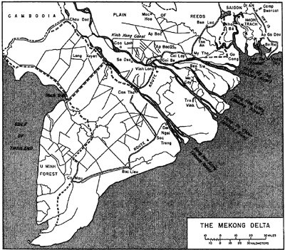
[17]
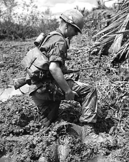
SOLDIER STRUGGLES THROUGH DELTA MUD
The delta had poor overland communications. Crisscrossed by a complex network of rivers, canals, streams, and ditches, the low, poorly drained surface was subject to extensive and prolonged inundation. There was only one major hard surface road, Route 4, which extended from Saigon south to Ca Mau, traversing the delta and linking many of the larger towns. Secondary roads were poorly surfaced, and by the mid-1960's had deteriorated because of lack
[18]
of maintenance and enemy action. The waterway system made frequent bridging necessary; bridge capacities were mainly in the 10- to 20-ton range. In short, the roadnet was of limited use for military operations.
Any movement off the roads was limited. It was best during the dry season-November to March-when paddies were dry and would support light tracked vehicles and artillery pieces; it was poorest during the wet, season-May to October-when paddies were inundated. It was restricted all year round by the network of rivers, canals, streams and ditches. There were many swamps, marshes, and forests, generally bordering the seacoast.
In comparison with most of the other areas of Vietnam, the Mekong Delta was good for air operations, since landing zones were abundant and weather seldom prevented helicopter operations. Once troops debarked from helicopters, however, their movement wag sharply restricted by ditches and waterways.
In sharp contrast to the limited overland transportation, the delta had a highly developed inland waterway system. There is evidence that the inhabitants began to improve natural drainage as early as 800 A.D., and succeeding generations have continued the work. As a result, the 2,400 kilometers of navigable natural waterways were supplemented by about 4,000 kilometers of land-cut canal of varying width and depth, and in good to poor condition.
The wet season, the tune of the southwest monsoon, permits deliberate flooding of rice paddies, but also causes some unavoidable flooding as rivers overflow their hanks. Waterways grow wider, sharply curtailing cross-country traffic and limiting the amount of firm ground suitable for placing artillery. Off-road movement of troops and vehicles can cause damage to crops and drainage systems, and was therefore unpopular with the farmers. Further, the high humidity and extensive flooding aggravated the foot problems of the soldier, who got his feet wet from frequent water crossings. One-third of the delta is marsh, forest, or swamp forest. In the north lies tile Plain of Reeds, a flat, grassy basin with almost no trees. During the wet season it is generally inundated to a depth of two to three meters; during the dry season, much of the plain dries out to the extent that large grass fires are frequent. There are relatively few points in the delta that lie more than a few hundred meters from a navigable waterway; even the marshes, swamps, and forests can be reached by water. In short, the delta is well suited to riverine operations.
[19]
Military operations on the waterways of the Mekong Delta had to be governed by the life of the delta. By any standard, the delta is densely populated; it has an average of about 200 inhabitants per square kilometer, about the same density as Massachusetts. The people are concentrated along the waterways that constitute their principal transportation routes. Transportation, essential to the people and to the national economy, felt the impact of military operations, and the U.S. commander was obliged to maneuver his forces so as to interfere as little as possible with the normal flow of civilian transport.
Where people lived there were trees and bushes cultivated for their fruit, shade, or decoration. Since these offered protection to an enemy seeking concealment, military engagements often took place in populated areas. Thus a commander was faced with the task of inflicting damage on an armed enemy, and at the same time trying to avoid damage to the unarmed local inhabitants. High population density makes it difficult to conceal military activity from observation; weaknesses may be noted and word passed to the enemy, moves may be telegraphed before they can achieve their purpose.
Seacoasts of the delta have extensive mangrove swamps, including the Rung Sat southeast of Saigon, and the U Minh Forest along the west coast; vegetation on the tidal mudflats is dense, root structure is high and tangled, and covering is thick, making access difficult and cross-country movement arduous. The paddy land is interspersed with thickets of trees and bushes in patterns that vary; in one area vegetation is clustered polka-dot style about scattered dwellings; a few kilometers away, it is in continuous strips along waterways. There are large cultivated plantations-rows of palm trees grown on embankments which alternate with wide drainage ditches. In the wide-ranging operations characteristic of riverine warfare, it was necessary to adapt tactics to the lay of the land.
Riverine operations in the delta also had to deal with the strong influence of sea tides along the inland waterways throughout the region. Tidal fluctuations range up to about four meters. The twice daily tidal flow influences the velocity of currents, and has an important bearing on the feasibility of navigation in many waterways. Variations in sea tides, together with the complex nature of the interconnecting waterways, make tidal effects exceptionally difficult to predict with confidence. As a consequence, planning for water operations involves a good deal of guesswork, for the time required to travel from one point to another cannot be predicted.
[20]
The condition of the inland waterways added obstacles to military movement. By 1960 many canals had deteriorated from neglect; of some 1,500 surveyed that year, nearly half required "restoration," and could carry traffic only at full tide. Some waterways had been deliberately obstructed by the enemy. In the smaller streams there were many fishtraps that restricted passage. Bridges are always to be dealt with in waterborne movement, since frequently there is not enough clearance to permit passage of vessels. This problem is further complicated by variation in water levels due to tidal fluctuations, which may permit passage for short periods twice a day only.
Finally, it was difficult to base troops in the Mekong
Delta since firm ground was limited. Military needs for land bases tended to
conflict with the needs of the population, so that a floating base offered a
clear advantage. .
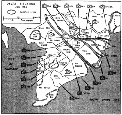
As elsewhere in Vietnam, the enemy had in 1966 and early 1967 both a political and a military organization in the delta. In mid-1966 estimated strength of the Viet Cong in the IV Corps Tactical Zone, which corresponds roughly to the delta, was 82,545 men. Of these, 19,270 were combat troops; 1,290 were support troops; 50,765 were local part-time guerrillas; and 11,220 were working as political cadre. At the time, no North Vietnam Army forces were reported in the IV Corps Tactical Zone. In the summer of 1966 the office of the assistant chief of staff for intelligence estimated that organized military forces in the IV Corps Tactical Zone consisted of three regimental headquarters, 28 battalions (8 of which were in the regiments) , 69 separate companies, and 11 separate platoons-an estimate that agreed closely with that of U.S. Military Assistance Command, Vietnam. (Map 3)
It was believed that Viet Cong logistics depended on support from the population, on captures from Republic of Vietnam units, and on supplies furnished by the Democratic Republic of Vietnam -primarily weapons and ammunition-infiltrated by sea, or by land from Cambodia. The base area was believed to be fundamental to the Viet Cong logistical system. Base areas such as the Plain of Reeds, the U Minh Forest, and the Cam Son Secret Zone west of My Tho served as sites for political, military, logistical, and training installations, and were supplemented by "combat villages" on South Vietnamese territory, organized and controlled by the Viet Cong. Cambodia provided a rear service area for 10,000 or
[21]
more main and local Viet Cong forces in Vietnamese provinces that offered free access to Cambodian territory.
Viet Cong forces in the delta were as well armed as those elsewhere in Vietnam. The new family of 7.62-mm. weapons manufactured by the Chinese Communists were first captured in the delta on 11 December 1964 by Republic of Vietnam armed forces. The capture included copies of the AK47, the SKS carbine, the RPD light machine gun, and a quantity of M43 intermediate 7.62mm. cartridges of Soviet design. During the same month, the Vietnam Army also captured the first RPG2 antitank grenade launcher, capable of penetrating six to seven inches of armor at ranges of 100 to 200 meters-a potent weapon for use against riverine craft.
Viet Cong communications equipment, while not abundant, appeared adequate. The enemy was able to interfere with and intrude on voice circuits of U.S. and South Vietnam forces, blanking out transmissions and employing tactical deception.
Viet Cong methods of operation in the delta were not sub-
[22]
stantially different from those employed by the enemy in
other regions. In 1966 it was reported that Viet Cong activities had been
primarily small unit operations-harassment, terrorism, and sabotage, with the
delta accounting for approximately one-third of all Viet Cong initiated
incidents in South Vietnam. The enemy, however, was also able to mount
battalion-size attacks. Several times the Viet Cong demonstrated a willingness
and an ability to slug it out with government forces. In January 1963 at Ap Bac
a Viet Cong force engaged a superior Army of Vietnam force that was attempting
to surround the Viet Cong by using heliborne assault in conjunction with
conventional ground movement. Five helicopters were destroyed and nine damaged
as the Viet Cong inflicted heavy casualties and withdrew. In December 1964 the
Viet Cong 9th Division with two regiments seized the Catholic village of Binh
Gia. During the next four days the enemy ambushed and virtually destroyed the
Vietnamese 33d Ranger Battalion and 4th Marine Battalion and inflicted heavy
casualties on armored and mechanized relief forces.
In 1966 most of the Mekong Delta was included in the IV Corps Tactical Zone, although Gia Dinh Province, Long An Province, and the Rung Sat Special Zone in the north were part of the III Corps Tactical Zone. The IV Corps Tactical Zone was in turn subdivided into three division tactical areas. In the north the 7th Division had its headquarters at My Tho; in the center was the 9th Division with headquarters at Sa Dec; and in the south was the 91st Division with headquarters at Bac Lieu. In 1966 Army of Vietnam assigned strength in IV Corps Zone averaged 40,000. In addition to the three divisions, there were five Ranger battalions and three armored cavalry squadrons.
South Vietnam paramilitary forces included Regional Forces, Popular Forces, Civilian Irregular Defense Group (CIDG) troops, and National Police. In 1966 Regional and Popular Forces manned outposts and watchtowers scattered throughout the delta. Poorly supported and highly vulnerable to Viet Cong attack, both these forces had high desertion rates. The Civilian Irregular Defense Group troops were employed generally along the Cambodian border as part of an effort to seal the frontier against Viet Cong and North Vietnamese movements of men, equipment, and supplies. The National Police were organized after the manner of the French gendarmerie, and exercised similar functions.
[23]
Vietnam naval forces attached to the Vietnamese 4th Naval
Zone in the delta included six river assault groups, which had evolved directly
from the French Dinassauts, and eleven coastal groups known collectively as the
junk Fleet. The assault groups were under the operational control of the IV
Corps commander with the primary mission of supporting Vietnam Army riverine
operations. Each group could lift a Vietnamese infantry battalion, giving the IV
Corps Zone the capability of a six-battalion lift. The river assault groups were
in 1966 being used in their primary role only 10 percent of the time. Vietnam
Army division commanders apparently preferred airmobile operations to riverine
operations, hence the river assault groups were employed in support of small
unit operations by Regional or Popular Forces under the control of province
chiefs. Often they were used simply as escort for commercial craft.
The American military first entered the Mekong Delta in 1957 when U.S. Navy advisers replaced French advisers. By early 1966 the American advisory effort had permeated the Republic of Vietnam military structure. Advisers included nearly 700 officers and over 2,000 enlisted men from the U.S. Army, Navy, and Air Force. American Army advisers were present at corps, division, and sector (province) level, and with the IV Corps Tactical Zone Area Logistics Command. The U.S. Navy Advisory Group, Vietnam, provided advisers to the Vietnamese Navy's six river assault groups and eleven coastal groups.
In 1965 the U.S. Army 13th Combat Aviation Battalion had
been sent to the delta to support Republic of Vietnam operations, and by August
of that year the battalion had four assault helicopter companies and one
reconnaissance airplane company. By mid1966, U.S. naval forces included Task
Force 115, with the code name MARKET TIME, and Task Force 116, known as GAME
WARDEN. MARKET TIME had the mission of patrolling coastal areas to prevent
resupply of Viet Cong and North Vietnam forces by sea. GAME WARDEN had the
mission of interdicting enemy lines of communications and assisting government
forces in repelling enemy attacks on river outposts of the Regional and Popular
Forces.
In April 1964 the American Ambassador, Henry Cabot Lodge, Jr., had remarked: " - - . I would not be surprised to see the
[24]
Mekong Delta totally cleared of Communist forces by the end of 1965." In the summer of 1966, however, the Military Assistance Command, Vietnam, reported that about one-third of all Viet Cong actions against the government in South Vietnam occurred in the IV Corps Tactical Zone, and estimated that the Viet Cong controlled 24.6 percent of the population of IV Corps.
Government influence varied widely from province to province. An Giang Province was considered "pacified," while in An Xuyen Province it was estimated that government forces controlled as little as 4 percent of the land. In many areas government forces claimed control by day, but acknowledged that the "night belongs to the Viet Cong." With few exceptions, the large towns served as either province or district capitals and in 1966 were largely under government control. All, however, were occasionally subject to terrorist incidents, mortals or rocket attacks, or assaults upon outlying guard posts. The Viet Cong was, furthermore, choking off the flow of rice to market: in 1963 rice arriving at the market in Saigon reached a high of about four million metric tons; in 1966 amounts declined to about three million tons, making importation of rice necessary. Far from being "totally cleared of Communist forces," in 1966 the delta was more than ever under Viet Cong control and something different was going to have to be done to change the situation. The introduction of additional forces might help, but such forces would require bases, which were difficult to provide. It was against this background that the basic decisions for the creation of an American riverine force were made in late 1965 and early 1966.
[25]
![]()
